Saved Bookmarks
This section includes InterviewSolutions, each offering curated multiple-choice questions to sharpen your knowledge and support exam preparation. Choose a topic below to get started.
| 1701. |
Which one of the following rivers has the largest river basin in India? |
|
Answer» The INDUS |
|
| 1702. |
Why does Shillong receive more rainfall than kolkata ? Give two reasons. |
|
Answer» Solution :SHILLONG is situated on the meghalaya Plateau which receives the HIGHEST RAINFALL in the country. (i) Shillong is situated on lofty MOUNTAINS, funnel shaped. Here condensation is intense causing heavy rainfall. (II) Kolkata is located on the Ganga - Brahmaputra Delta. There is no mountain range obstructing the South west monsoon. Hence, it receives less rainfall. |
|
| 1703. |
Which of the following hills are not a part of eastern ghats? |
|
Answer» JAVADI hills |
|
| 1704. |
Which countries have more than one time zone? |
| Answer» Solution :The COUNTRIES with large-west span may CHOOSE more than one standard meridian to GET more than one time ZONE such as Russia. Canada and the UNITED States of America. | |
| 1705. |
Where do tropical cyclones originate Which states states do they hit the most ? |
| Answer» Solution :TROPICAL cyclones ORIGINATE over the Bay of Bengal and the Indian Ocean. These tropical cyclones have very high wind velocity and HEAVY rainfall and hit the Tamil Nadu, Andhra Pradesh and Odisha COAST. Most of these cyclones are very destructive due to high wind velocity and torrential rain that ACCOMPANIES it. | |
| 1706. |
Where was oldest map found? |
| Answer» Solution :The oldest MAP was FOUND in Mesopotamia drawn on a CLAY TABLET that belongs to 2,500 B.C. | |
| 1707. |
Write a short note on map interpretation. |
| Answer» Solution :Map INTERPRETATION involves the study of FACTORS that explain the causal relationship among several FEATURES shown on the map. For example, the distribution of natural vegetation and cultivated land can be better understood against the background of landform and drainage. Likewise, the distribution of settlements can be examined in association with the LEVELS of transport NETWORK system and the nature of topography. | |
| 1708. |
Who had developed Mercator projection? |
|
Answer» Mercator Gerardus Karmer |
|
| 1709. |
Which of the following river falls into Arabian Sea ? |
|
Answer» MAHANADI |
|
| 1710. |
Which one of the following rivers flows in a rift valley ? |
|
Answer» The SON |
|
| 1711. |
When was comprehensive Wildlife Act enacted and what are its objectives? |
|
Answer» SOLUTION :In 1972, comprehensive Wildlife Act was enacted. (i) To PROVIDE protection to the ENDANGERED species listed in the schedule of the act. (ii) To provide legal support to the conservation areas of the country CLASSIFIED as national parks, sanctuaries and closed areas. (iii) Making punishments more stringent and has also made provisions for the protection of specified PLANT species and conservation of endangered species of wild animals. |
|
| 1712. |
Which department prepares the weather map of India for each day? |
|
Answer» The World METEOROLOGICAL ORGANISATION Solution :The INDIAN Meteorological DEPARTMENT |
|
| 1713. |
Why can we use aerial photographs as historic record? |
| Answer» Solution :An AERIAL photograph is a record of the SURFACE FEATURES at an INSTANCE of exposure. It can, therefore, be used as a historical record. | |
| 1714. |
What percent of sunrays that is received by the upper layer of the atmosphere reach the earth surface? |
| Answer» Answer :B | |
| 1715. |
Write a detailed note on Coriolis Force. |
|
Answer» SOLUTION :The rotation of the earth about its axis affects the direction of the wind. This force is called the Coriolis force after the French physicist who described it in 1844. It deflects the wind to the right direction in the northern hemisphere and to the left in the wouthern hemisphere. The deflection is more when the wind velocity is high. The Coriolis force is directly proportional to the angle of latitude. It is maximum at the poles and is absent at the equator. The Coriolis force acts perpendicular to the pressure GRADIENT force. The pressure gradient force is perpendicular to an isobar. The higher the pressure gradient force, the more is the velocity of the wind and the larger is the deflection in the direction of wind. As a result of these two forces OPERATING perpendicular to each other, in the LOW-pressure areas the wind blows aroundit. At the equator, the Coriolis force is zero and the wind blows perpendicular to the isobars. The low pressure gets filled instead of getting intensified. |
|
| 1717. |
When was National Forest Policy adopted in India? |
| Answer» Solution :NATIONAL Forest POLICY was adopted in 1952 under which Forest Conservation BOARD was established. This policy was modified in 1988. | |
| 1718. |
Where can you find natural vegetation? |
| Answer» Solution :We can find NATURAL VEGETATION in those AREAS where climate and soil are suitable for plant growth. Depending UPON the variations in the climate and the soil, the vegetation of India changes from ONE region to another. | |
| 1719. |
Which type of climate exist in Plateau Station , Antarctica , 79°S according to Koeppen? |
|
Answer» TUNDRA CLIMATE |
|
| 1720. |
Which areas have more than 50 cm and less than 5 cm of rainfall in July ? Why is it so ? |
| Answer» Solution :Most areas of the country have more than 50 cm of rainfall in July. The western Rajasthan (THAR Desert) and the North-eastern Ladakh experience less than 5 cm. rainfall in July. Due to parallel SITUATED of Aravalis, lack of vegetation, high temperatures and non-condensation of moisture in western Rajasthan rainfall is very scanty. The Zaskar range does not ALLOW the monsoon winds to reach North - eastern Ladakh. Hence it also receives very scanty rainfall during July. | |
| 1721. |
Write an explanatory account of types of maps |
Answer» SOLUTION :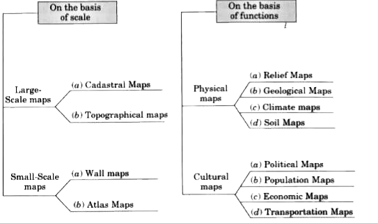
|
|
| 1722. |
Which of the following country is not a mega diversity centre? |
|
Answer» INDIA and CHINA |
|
| 1723. |
According to Wegener, what are the causes of drifting of continents? |
|
Answer» Solution :A number of discoveries during the post- war period ADDED new information to geological LITERATURE. Particularly, the information collected from the OCEAN floor mapping provided new dimensions for the study of distribution of oceans and continents. (a) These currents are generated due to radioactive elements causing thermal differences in the mantle portion. Holmes argued that there exists a system of such currents in the entire mantle portion. This was an attempt to provide an explanation to the issue of force, on the basis of which contemporary scientists discarded the continental DRIFT theory. (b) Detailed research of the ocean configuration revealed that the ocean floor is not just a vast plain but it is full of relief. (c) Expeditions to map the oceanic floor in the post-war period provided a detailed picture of the ocean relief and indicated the existence of submerged mountain ranges as well as deep trenches, mostly located closer to the CONTINENT margins. (d) The mid-oceanic ridges were found to be most active in terms of volcanic eruptions. The dating of the rocks from the oceanic crust revealed the fact that they are much younger than the continental areas. (e) Rocks on either side of the crest of oceanic ridges and having equi-distant locations from the crest were found to have remarkable similarities both in terms of their constituents and their age. |
|
| 1724. |
Where is Sunderbans biosphere reserve located? |
| Answer» Solution :In Ganga river delta | |
| 1725. |
Write short notes on the following: (i) Safe place for a thermometer (ii) Indian Daily Weather report . |
|
Answer» Solution :(i) Safe place for thermometer: It is not safe to keep a thermometer in sunlight. We should also not keep it in airtight surroundings. The Stevenson screen is designed to protect thermometers from precipitation and direct sunlight while allowing AIR to circulate FREELY around them. It is made from wood with louvered sides to allow FREE and even flow of air. It is painted white to reflect radiation. The purpose of the Stevenson screen is to create a uniform temperature enclosure that closely represents the same temperature as the air outside. It stands on four legs and is about 3 feet 6 inches above the level of the ground. The legs must be sufficiently rigid and be buried sufficiently in the ground to prevent shaking. The front panel is hinged at the bottom to form a door, which allows for maintenance and reading of the thermometers. The door of Stevenson screen is always TOWARDS the north in the northern hemisphere and towards the south in the southern hemisphere because direct sunrays also affect mercury. (ii) Indian Daily Weather Report: IMD became a member of the World Meteorological Organization after independence on 27 April 1949. The agency has gained in prominence due to the significance of the monsoon rains on Indian agriculture. It plays a vital role in preparing the annual monsoon forecast, as well as in TRACKING the progress of the monsoon across India every season. IMD undertakes observations, communications, forecasting and weather services. In collaboration with the Indian Space Research Organisation, the IMDalso uses the IRS series and the Indian National Satellite System (INSAT) for weather monitoring of the Indian subcontinent. IMD was the first weather bureau of a developing country to develop and maintain its own satellite system. IMD is one of the 6 worldwide Regional Specialized Meteorological Centers of the Tropical Cyclone Programme of the World Weather Watch of the World Meteorological Organization. It is regional nodal agency for forecasting, naming and disseminating warnings about tropical cyclone in the Indian Ocean north of the Equator. |
|
| 1726. |
Which of the following country is not included in Indian subcontinent? |
|
Answer» PAKISTAN |
|
| 1727. |
Why do the rich countries and the poor countries differ so much in terms of the nature of their disaster consequences? |
| Answer» Solution :Poor people, and likewise poor COUNTRIES, tend to be much more vulnerable to events that exceed their capacity to withstand DISASTER impacts and to respond once a disaster has occurred. They are also much less likely to effectively recover in the aftermath of a disaster event. (i) The interaction between exposure and vulnerability can explain a lot about a country.s disaster profile. The instructor can illustrate the relationship between DISASTERS and vulnerability by providing the students with an example of similar disaster events that occur in two different countries - one that is wealthy and one that is poor. (ii) In most wealthy countries, an event of this magnitude causes little damage, very few injuries, and rarely any fatalities. However, in poor countries, it is not uncommon for a seismic event of this scale to cause significant injuries and fatalities. (iii) In the wealthy countries, where buildings are constructed to CODE, and ENFORCEMENT is effective, vulnerability is low to a magnitude 6.0 event. However, in poor countries, it is not uncommon for structures to be built in an informal fashion (out of traditional materials, including mud and stone, for example), with no consideration or enforcement of resistant building codes. In the event of a moderate earthquake, such as a 6.0 magnitude event, these informal structures can collapse. (iv) It is poverty, and the many factors associated with poverty (such as corruption, poor access to building skills, knowledge, and materials, and other reasons), that create the vulnerability gap between the rich and the poor countries. | |
| 1728. |
Which of the following is not a quality of globe? |
|
Answer» Accurate shape of a REGION |
|
| 1729. |
What per cent of earth mass is constituted by air and it is confined to what height? |
| Answer» Solution :The air is an integral part of the earth.s MASS and 99 PER cent of the TOTAL mass of the atmosphere is confined to the HEIGHT of 32 km from the earth.s SURFACE. | |
| 1730. |
What was the name given by Alfred Wegener to a large continent surrounded with water? |
|
Answer» PANGAEA |
|
| 1731. |
Which of the following has longest day and nights? |
|
Answer» Poles |
|
| 1732. |
Write a short note on developable surface and zenithal projections. |
|
Answer» Solution :A developable surface is one, which can be flattened, and on which, a network of LATITUDE and longitude can be projected. A cylinder, a cone and a plane have the property of developable surface. On the basis of nature of developable surface, the projections are classified as cylindrical, CONICAL and zenithal projections. (i) Cylindrical Projections: These are made through the use of cylindrical developable surface. A paper-made cylinder covers the globe, and the parallels and meridians are projected on it. (ii) Zenithal projection: It is directly obtained on a plane surface when plane TOUCHES the globe at a point and the graticule is projected on it. Generally, the plane is so placed on the globe that it touches the globe at one of the poles. These projections are further subdivided into normal, OBLIQUE or polar as per the position of the plane touching the globe. (a) Normal Projection: If the developable surface touches the globe at the equator, it is called equatorial or normal projection. (b) Oblique Projection: If it is tangential to a point between the pole and the equator, it is called the oblique projection, (C) Polar Projection: If it is tangential to the pole, it is called the polar projection. |
|
| 1733. |
Wind and water are two important agents of soil erosion. Explain. |
| Answer» SOLUTION :Wind and water are powerful agents of soil erosion because of their ability to remove soil and transport it. Wind erosion is significant in arid and semi-arid regions. Erosion by running water is more significant in regions with heavy rainfall and steep slopes. water erosion which is more serious and occurs extensively in different parts of india, takes place mainly in the form of sheet and gully erosion. sheet erosion takes place on level lands after a heavy shower and the soil REMOVAL is not easily noticeable. but it is harmful since it removes the finer and more fertile top soil. gully erosion is common on steep slopes. gullies deepen with rainfall, cut the agricultural lands into SMALL fragments and make them unfit for cultivation. a region with a large NUMBER of deep gullies or ravines is called bad land topography. Ravines are widespread, in the chambal basin. they are also FOUND in tamil nadu and west bengal. the country is losing about 8,000 hectares of land to ravines every year. | |
| 1734. |
Which of the following is an example of endogenic forces? |
|
Answer» Erosion |
|
| 1735. |
Write short notes on Contours |
|
Answer» Solution :Some BASIC features of contour lines are: (a) A contour LINE is drawn to show places of equal heights. . (b) Contour lines and their SHAPES represent the height and slope or gradient of the landform. . (c) Closely spaced contours r epresent STEEP slopes while widely spaced contours represent gentle slope. . (d) When two or more contour lines merge with each other, they represent features of verticals lopes such as cliffs or waterfalls. . (e) Two contours of different elevation USUALLY do not cross each other. |
|
| 1736. |
What type of climatic conditions would prevail if the sun spots increase? |
| Answer» Solution :Sunspots are DARK and cooler patches on the sun which increase and DECREASE in a cyclical manner. ACCORDING to some meteorologists, when the number of sunspots increase, cooler and wetter WEATHER and greater storminess occur. A decrease in sunspot NUMBERS is associated with warm and drier conditions. | |
| 1737. |
Which one of the following facts was not considered by those while discussing the concept of sea floor spreading? |
|
Answer» 1. Volcanic activity along themid- oceanic ridges |
|
| 1738. |
What steps have been taken up to conserve forests? |
|
Answer» Solution :Following steps have been taken up to conserve forests: (a) Social forestry: Social forestry means the management and protection of forests and afforestation on barren lands with the purpose of helping in the environmental, social and rural DEVELOPMENT. The National Commission on Agriculture (1976) has classified social forestry into three categories. Urban forestry: Urban forestry pertains to the raising and management of trees on public and privately owned lands in and around urban centres such as green belts, parks, roadside avenues, industrial and commercial green belts, etc. Rural forestry: Rural forestry lays emphasis on promotion of agro-forestry and community-forestry. Farm forestry: Agro-forestry is the raising of trees and agriculture CROPS on the same land inclusive of the waste patches. It combines forestry with agriculture, thus, altering the simultaneous production of FOOD, fodder, fuel, timber and fruit. (b) Community forestry: Community forestry involves the raising of trees on public or community land such as the village pasture and TEMPLE land, roadside, canal bank, strips along railway lines, and schools, etc. Community forestry programme aims at PROVIDING benefits to the community as a whole. (c) Farm forestry: Farm forestry is a term applied to the process under which farmers grow trees for commercial and non-commercial purposes on their farm lands. Forest departments of various states distribute seedlings of trees free of cost to small and medium farmers. |
|
| 1739. |
Why is remotesensing a bettertechnique than other traditional methods ? |
| Answer» Solution :Remotesensing is a better TECHNIQUE than traditionalmethods because it presents theconcise pictureof a large AREA, provides real or nearlyreal PICTURES on time base line , it is less expensive as compared to landsurvey andwe can easily COLLECT information by usingit . It CONVERTS energy received into photographic/digital from of data. Itis not affected bybad weather and inaccessible land . | |
| 1740. |
Which of the following is not a feature of black soil ? |
|
Answer» It is suitable for the culvation of cotton. |
|
| 1741. |
Which of the following projection is not classified on the basis of source of light? |
|
Answer» GNOMONIC PROJECTION |
|
| 1742. |
Which of the following is a systematic process? |
| Answer» Solution :Balanced Erosion | |
| 1743. |
Which of the following is not a type of biome? |
| Answer» Solution :Sundri biome | |
| 1744. |
Where do waves in the ocean get their energy from? |
| Answer» SOLUTION :Wind provides energy to the waves. Wind causes waves to travel in the ocean and the energy is RELEASED on shorelines. The motion of the surface water seldom affects the stagmant deep bottom water of the oceans. As a wave approaches the beach, it slows down. This is due to the FRICTION occurring between the dynamic water and the sea floor. Waves continue to grow larger as they move and absorb energy from the wind. Most of the waves are caused by the wind driving against water. When a breeze of two knots or LESS blows over calm water, small ripples form and grow as the wind speed increases until WHITE caps appears in the breaking waves. | |
| 1745. |
When front becomes constant, it is called: |
|
Answer» Cold front |
|
| 1746. |
Which map projection is very useful for navigational purposes? Who developed it and on what is it based? |
| Answer» Solution :Mercator.s PROJECTION is very useful for navigational PURPOSES. A DUTCH cartographer Mercator Gerardus Karmer developed this projection in 1569. The projection is BASED on MATHEMATICAL formulae. | |
| 1747. |
Which letter code did Koeppen use for following temperature ranges? (i) Average temperaiu1·e of the coldest month is 18° or higher. (ii) Average temperature for all months is below 10° C. (iii) Average temperature of the coldest month is -3° or lower. (iv) Average temperature of the coldest month is higher than -3° but less than 18°. |
|
Answer» SOLUTION :(i) A - Tropical climates (II) E - Cold Climates (III) D - Cold Snow FOREST Climates (iv) C - WARM Climates. |
|
| 1748. |
What methods are used to present topography? |
| Answer» Solution :A NUMBER of methods have been used to show the relief features of the Earth.s surface on maps, over the years. These methods include hachure, hill shading, layer tints, benchmarks and spot HEIGHTS and contours. However, contours and spot heights are PREDOMINANTLY used to depict the relief of an AREA on all topographical maps. | |
| 1749. |
Which of the following area come under tropical wet climate? |
|
Answer» AMAZON Basin in South America |
|
| 1750. |
Which rocks are formed by metamorphism of lime stone? |
| Answer» Solution :Schist | |